
DOUG WIGGANS SAID:
Anthony [Marsh], the photo I linked clearly shows the curb that divides Main from Elm, as it extends from the triple underpass heading to the West (still there as of 8-28-08). The point of the post was asking about the curb dividing Elm from Main, no mention of an island, spectators, Gilligan, & Mary Ann!
ANTHONY MARSH SAID:
It does not clearly show and you do not point out exactly what you are talking about. Seems some innocent readers assumed you mean the island. A median strip is not an island. .... It was not easy to get directly from Main to the Stemmons on-ramp. Elm St. was the correct way to do it. Much cleaner than driving over the grass.
DAVID VON PEIN SAID:
Exactly. I've got to side with Tony Marsh on this particular issue. The fairly small concrete "barrier" that prohibits traffic from getting from Main directly onto the Stemmons ramp is hard to discern in this photograph (at least the tip of that barrier isn't visible, at any rate):

Just compare the above picture to Commission Exhibit 2116:
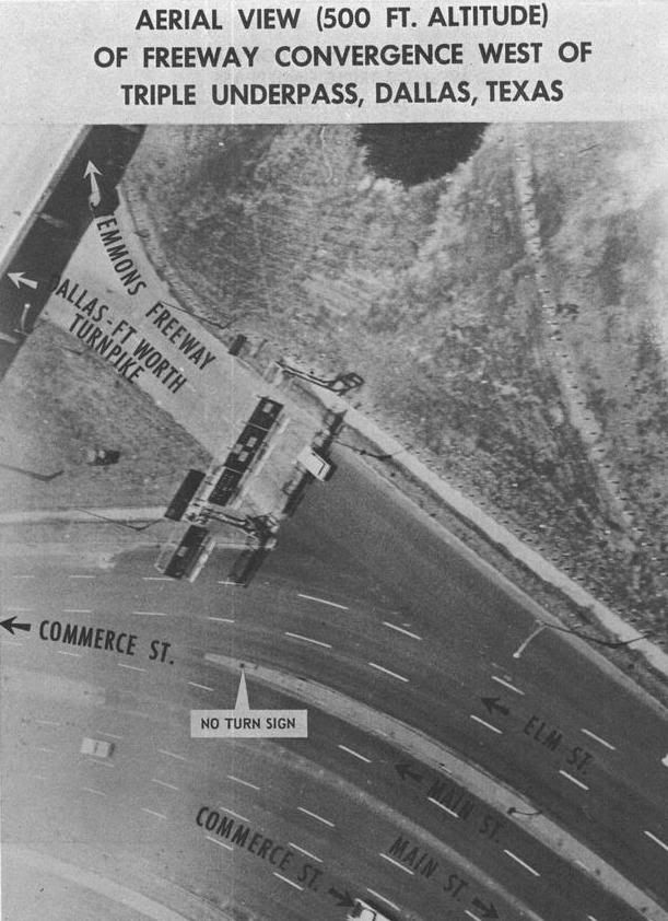
The concrete barrier is clearly visible in CE2116. Of course, from the air, it's impossible to see just exactly how high that barrier is. But it couldn't be any more obvious (via CE2116) that a definite lane restriction WAS in place on 11/22/63 that prevented traffic from getting onto Stemmons directly from Main Street.
DOUG WIGGANS SAID:
Anthony, the picture I posted shows the curbing about as clear as any picture that I am aware (btw DVP, belated thanks for access to the photo thru your site). I'll give the viewer enough credit to figure out where the curb is located in the picture. It's not like I'm trying to describe a black dog man hidden in the bushes within the photo.
DVP, you need to take a much closer look (btw, I lifted the photo link from your site). The curb appears in the photo [pictured again below; click on the image to enlarge] as a dark line that is quite easily seen immediately to the right of the white unmarked car of Curry. Look above the Queen Mary and you will see the continuation of the same curb on the other side of the triple underpass up into Dealey Plaza.
The reason the curb appears as a darkened line is due to the shade being produced by the angle of the sun at the time of the photo being taken. As it appears in the photo, a viewer can easily discern that the curb allowed a motorist driving down Elm to either access Stemmons Freeway ramp or merge further down with Main onto Industrial Blvd. without having traffic from Main being able to cut across Elm and onto the ramp to Stemmons.
Nothing much has changed along this route in 40+ years. I took pictures of the exact same view last November [2007; see the photos below]. It's all still there.
DAVID VON PEIN SAID:
Doug,
Excellent comparison pictures of Elm and Main Streets at the Stemmons Freeway ramp area. I can see exactly where the concrete barrier is located now, via your clearer photo taken in 2007. Here's a direct comparison:


And here's another photo from a different angle, which shows the end of the concrete barrier between Main and Elm Streets:

Thanks, Doug, for the excellent 2007 comparison photos. And in the first photo above, it looks like you're in the exact same location (almost to the inch) that Mel McIntire was in when he took his famous "Limo Coming At Me" picture on 11/22/63.
Nice job at replicating the location of the McIntire picture.
David Von Pein
August 29, 2008
August 30, 2008
February 1, 2013
